
You are here: Start » Filter Reference » Geometry 2D » Geometry 2D Spatial Transforms » PointAlongPath
 Advanced
| Module: | FoundationLite |
|---|
Transforms a point to a coordinate system in which the 'axis' path is vertical or horizontal.
Applications
| Name | Type | Description | |
|---|---|---|---|
 |
inPoint | Point2D | Input point |
|
inAxis | Path | Input axis path |
|
inAxisType | Axis | Type of axis the input axis path is parallel to |
|
inAxisCoordinate | Real | Coordinate of the axis path |
|
inInverse | Bool | Switches to the inverse operation |
 |
outPoint | Point2D | Transformed point |
Description
This operation transforms a point - inPoint - between two coordinate systems: the one linked with 'axis' path inAxis and the original one. Direction of this conversion is based on inInverse value:
- if it is true, inPoint is converted to original coordinate system
- if it is false, inPoint is converted from original coordinate system
Coordinate system linked with inAxis is some transformation of the original one, satisfying these conditions:
- 'axis' path is represented as a straight line
- 'axis' path is horizontal if inAxisType is set to X or vertical if inAxisType is set to Y
- if inAxisType is set to X, the Y coordinate of 'axis' path is equal to inAxisCoordinate. If inAxisType is set to Y, the X coordinate of 'axis' path is equal to inAxisCoordinate
Hints
- If this filter is used to reverse ImageAlongPath transformation you should set inAxis and inAxisType to the same values as corresponding ones in ImageAlongPath. inAxisCoordinate should be set to a half of ImageAlongPath.inScanWidth.
Examples
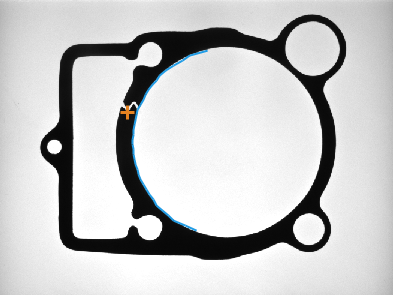 |
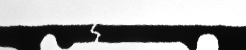 |
ImageAlongPath performed on the sample image with inAxisType = X, inScanWidth = 50 and path marked with blue. Point marked with blue cross on the output image was calculated by ScanSingleEdge. Original point (marked with orange cross) was calculated using PointAlongPath with inAxisType = X, inAxisCoordinate = 25, inInverse = true and position of detected point. ImageAlongPath and PointAlongPath used the same path for transformations.
Errors
This filter can throw an exception to report error. Read how to deal with errors in Error Handling.
List of possible exceptions:
| Error type | Description |
|---|---|
| DomainError | Empty path on input in PointAlongPath. |
Complexity Level
This filter is available on Advanced Complexity Level.
See Also
- ImageAlongPath – Creates an image from pixels traversed along a path.
- PathAlongPath – Transforms a path to a coordinate system in which the 'axis' path is vertical or horizontal.
- PointAlongArc – Transforms a point to a coordinate system in which the 'axis' arc is vertical or horizontal.